
Crosscut Trail System
Explore the neighborhood this season
With over 28 miles (45 km) of cross country and narrow-gauge trails maintained seven days a week, Crosscut Mountain Sports Center is the Bozeman community’s best location for cross-country skiing, snowshoeing, and fatbiking. From wide-groomed trails for skate and classic skiing, to narrow-gauge trails perfect for fatbiking and snowshoeing, it’s easy to find the ideal terrain for your snowy adventure.
Trailhead Sponsor
Integrated map and grooming report
Crosscut Mountain Sports Center is now on Nordic Pulse. This app includes our full ski trail map as well as up-to-date grooming information allowing our visitors to navigate our trail system with confidence. The app is free to download and use and does not require setting up an account — win-win!
Download the app on your smartphone: app for iPhone | app for Android

Trail Maps
Crosscut’s trail system is marked with signs, and many junctions have a trail map posted for on-the-ground navigation. But it never hurts to take a peek at our winter Trail Map before hitting the slopes. If you plan on fatbiking or snowshoeing, consider downloading the Narrow Gauge Trail Map before you head out.
Trail Descriptions
Check out the descriptions below for detailed trail information.
Cross-country skiing is allowed on all trails. Fat biking and snowshoeing are allowed on narrow gauge trails only. The narrow gauge trails are also great for classic skiing, but a bit narrow for skate skiing.
Looking for information on our summer trails?

On Native Land
Our programs are held on the ancestral homelands of the Niitsítpiis-stahkoii (Blackfoot), Apsaalooké (Crow), Salish Kootenai, Cheyenne, and Očhéthi Šakówiŋ (Sioux) peoples. We honor the past, present, and future of these Indigenous groups, and acknowledge their role as caretakers to this land.
Groomed Ski Trail Descriptions
Terrain and trails for Nordic skiers of all abilities
Our cross country trails are ideal for skate and classic skiing, beginners and experts alike. With 35 kilometers of trail groomed daily, multiple segments can be looped or combined for endless opportunities to experience the fun, the thrill, and the joy of Nordic skiing in a uniquely beautiful mountain setting.
Jump to descriptions of Narrow Gauge Trails (for snowshoeing, fatbiking, and classic skiing)
Kiddy K
0.9 km / 0.6 miles • 2-way trail
Kiddy K offers the easiest, most gentle way to get to Jane’s Gate. This two-way trail sneaks through large, widely spaced conifers allowing the winter sun to dapple through the branches.
North Bangtail
0.6 km / 0.4 miles • 2-way trail
Meander through pretty pines, climbing gently to the intersection of Jane’s Gate. This is the quickest way to get to Outer Trails such as Logger’s.
Cheétawaxaawe
0.35 km / 0.2 miles • 2-way trail — Learn how to pronounce Cheétawaxaawe
Cheétawaxaawe (pronounced “Chay-tuh-we-ka-wah”) is the Apsáalooke (Crow) place name for what we now call the Bridger Mountains. Cheétawaxaawe translates to “Wolf Mountains” in English. The Gallatin Valley has been an important place for tribal communities for thousands of years, and tribal communities knew the Wolf Mountains well. Many tribes came from every direction during the summer to hunt, gather plants and other materials, and trade with each other. The long, cold winters and hundreds of beaver dams were hallmarks of the Gallatin Valley. These factors combined to make the area a seasonal destination for people, bison, elk and deer. Because of this, the Gallatin Valley has always been a place of seasonal confluence and cultural exchange. Cheétawaxaawe is a two-way trail that winds through groves of aspen and conifer trees.
Love Lane
0.35 km / 0.2 miles • 2-way trail
Love Lane was named after Eric Love, Crosscut’s founder and long-serving Board Chair, who died tragically in the summer of 2022. This two-way trail is one of the most beautiful trails at Crosscut traversing sections of open meadow and shimmering aspen groves. We invite those who knew and loved Eric to spend time on all the Crosscut trails reflecting on his incredible life and legacy.
Warming Shelter Trail
0.4 km / 0.2 miles • 2-way trail
The most direct route from the base to the Warming Shelter building where visitors can take a load off, have a snack, and warm up by the fire. This two-way trail cuts through the middle of the meadow, and offers a spectacular view of Ross Peak.
Forsythe Meadow Trail
0.6 km / 0.3 miles • 2-way trail
This beautiful, easy loop is a good beginner trail. It doesn’t pass through the historic Forsythe Meadow; instead, it travels around the meadow’s edge through lovely aspens and evergreens. The Forsythe Meadow was formerly a property known as the Forsythe Ranch; the upper end of the meadow was the site of the original Crosscut Lodge in the early 1980s. Love Lane and Panorama are the best trails for exploring the historic Forsythe Meadow.
Panorama
0.3 km / 0.2 miles • 2-way trail
This trail name isn’t selling you short — it includes a gorgeous panorama of the Bridger Range. The trail skirts the edge of the historic Forsythe Meadow with a mature aspen grove on one side of the trail and open meadow on the other.
Piikani Trail: Ohkanaomowoo
0.2km / 0.15 miles • 2-way trail
Ohkanaomowoo is a Piikani (Blackfeet) word meaning “Gather Together from All Over.” Crosscut works to create a welcoming place for folks to gather and create community. This trail name honors the Piikani people who historically hunted and gathered in the Bridger Mountains and Gallatin Valley and their descendants who feel deep connection to the land. It was named in collaboration with Dr. Kim Paul the executive director of the Piikani Lodge Health Institute and a long-standing member of Amskapi Piikani Blackfeet traditional societies and ceremony. Learn more about this trail and the partnership between Crosscut and the Piikani Lodge Health Institute here.
Flyway
0.5 km / 0.27 miles • 2-way trail
Flyway trail was named in recognition of the Bridger Flyway. The Bridger Flyway is an important migration route for thousands of raptors every fall, most notably the Golden Eagle. Most migrants that fly over the Bridgers are making their way from Canada or Alaska to as far south as Central and South America. The flyway is noted for the largest concentration of Golden Eagles in the lower 48 states (up to 1,900 birds in a season!) with peak activity occurring in mid-October. The Bridgers not only provide important habitat for our resident wildlife, but also attract and support a notable abundance and diversity of southbound raptors each fall. Flyway is a two-way trail through Douglas fir trees. This trail is also an important part of our network of race-ready trails. and has two cutoff trails — Golden Eagle Cutoff and Great Horned Owl Cutoff — than can be used to dial in the exact length of race courses for different race events.
Blue-Green Trails:
Crosscut Loop
2.1 km / 1.3 miles • 2-way trail
Perfect for beginners, this trail is relatively flat and provides lovely scenery as it passes through beautiful aspen groves and around a great big meadow called the Forsythe Meadow. Climbing out of the meadow this trail gets a bit more challenging and turns into a blue trail traversing up and over the skier bridge. This trail is two-way — look out for other skiers and keep to the right around corners.
Five Rings
1.6 km / 1 mile • 2-way trail
Named for the five Olympic rings, this trail descends from Whiskey Gulch, through an open meadow. It continues on a fun downhill path all the way to the Pumphouse, then returns to the Nordic Center. The final section of Five Rings is part of the lighted loop for nighttime skiing. This trail is two-way — look out for other skiers and keep to the right around corners.
Intermediate (Blue) Trails
Meadow Loop
1.4 km / 0.9 miles • 2-way trail
A beautiful route that circumnavigates the edges of a picturesque meadow in a true loop. The Meadow Loop has a few rolling hills, passing by the Warming Shelter before returning towards Jane’s Gate. It includes Whiskey Gulch — a short, steep, fun dip and climb.
Agitos Alley
0.32 km / 0.2 miles • 2-way trail
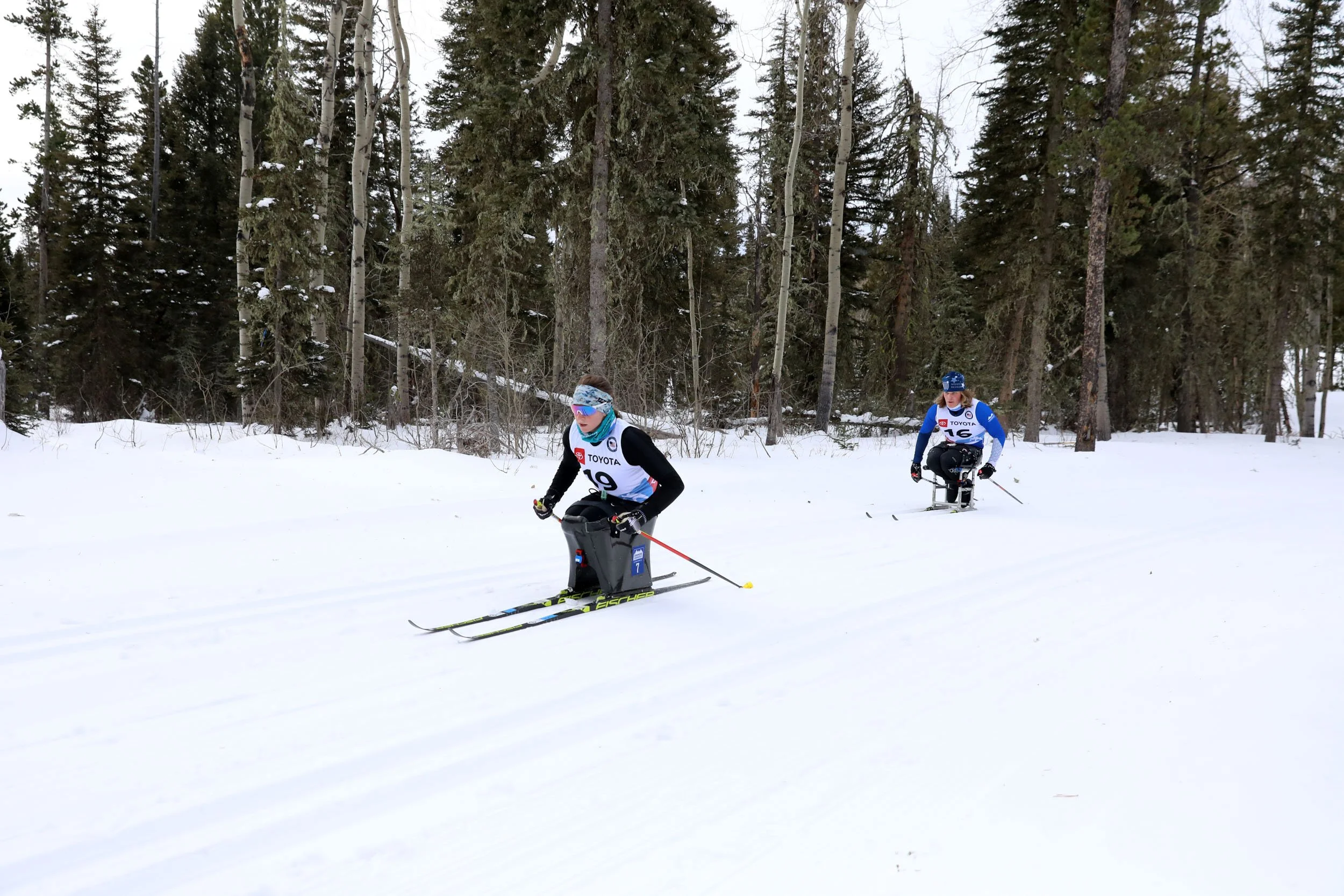
Agitos Alley (pronounced “ah-gee-toe”) was named by members of the U.S. Paralympic Nordic team. We are very proud for Crosscut Mountain Sports Center to serve as the training venue of the U.S. team and to have an integrated Elite Team with para and non-para athletes training side-by-side. The symbol of the Paralympic Games is composed of three agitos. Agitos means “I move” in Latin and the three agitos symbolize the Paralympic vision “to enable Paralympic athletes to achieve sporting excellence and inspire and excite the world.” Agitos Alley is a one-way trail that runs along the back side of the biathlon range steadily uphill. Near the intersection with Aspen there’s a clearing that allows for a lovely view of the biathlon stadium.

Agitos symbol
Lookout Trail
0.6 km / 0.3 miles • 2-way trail
Lookout Trail is a two-way route through rolling terrain, with a steady climb up to the “Lookout” highpoint — drink your hot chocolate at the Lookout picnic table while soaking in the view looking south down the canyon. Just downhill from the Warming Shelter, you can take the connector trail to Lookout, or keep more distance and approach via the longer way (via Whiskey Gulch). This connector trail is a short climb but fairly steep climb; look for the signpost which points to the right, or north, and says “Lookout.”
Montagne's Meander
1.8 km / 1.1 miles • Most sections are 2-way with one section that is 1-way
Montagne’s Meander is a loop trail that follows beautiful, rolling terrain through lodgepole forests as it circumnavigates a high point known as Downey’s Butte. Montagne’s Meander is mostly two-directional, with a short section of one-way traffic. These sections are well-marked so look for two-way and one-way signage.
Brackett Return
0.4 km / 0.2 miles • 1-way trail
Brackett Return is a gradual climb and short descent. This short, one-way trail segment connects the end of the more difficult section of the Brackett Creek Loop with Times Square, the major junction at the bottom of Logger’s.
South Bangtail
1 km / 0.6 miles • 1-way trail
Slightly more challenging than North Bangtail, with a few steeper downhill sections and a short climb near the end, South Bangtail is a one-way downhill segment that takes you from Jane’s Gate back to the base area.
Aspen
1.6 km / 1 mile • 2-way trail
Aspen Trail is a Crosscut favorite — a rolling trail that meanders through our most gorgeous old-growth aspen groves. This trail has two-way traffic so watch for other skiers.
Logger's
4.1 km / 2.5 miles • 1-way trail
Leaving Moose Junction, this trail climbs gradually for about one kilometer before taking a hairpin turn onto what used to be a logging road — the feature that gives Logger’s its name. The trail is a continuation of the South Fork of Brackett Creek Road, which begins at the Brackett Creek “Y” about two miles north of Crosscut on Bridger Canyon Road.
Between the junctions at the beginning and end of the Norway Trail, Logger’s is considered two-way traffic.The rest of Logger’s is one-directional.
Once on the old logging road section, Logger’s is relatively flat, with a final climbing “S” turn before reaching the high point. It’s all downhill from there. Watch for a fairly sharp left hand turn near the bottom as you approach the Times Square intersection.
Logger's Return
0.7 km / 0.4 miles • 1-way trail
A fun, mostly-downhill straightaway between the Times Square and Whiskey Gulch intersections.
Rollercoaster
0.4 km / 0.2 miles • 2-way trail
This intermediate, blue trail is fairly short and includes rolling hills. It begins at Five Rings and intersects the Aspen Trail. This is the first section of what will become a paved “roller-ski” loop for summer training.
Bridger Creek
1.0 km / 0.6 miles • 2-way trail
Bridger Creek is a two-directional trail that begins at the Nordic & Trail Center and intersects the Crosscut Loop at the north edge of the Forsythe Meadow.
Blue-Black Trail
Going Out
2.5 km / 0.2 miles • Partially 1-way, partially 2-way
Going Out Trail has two parts: an initial intermediate two-way segment followed by a longer and more difficult one-way segment. Going Out’s blue segment starts at Lookout Point and is a two-way trail. Its gently rolling terrain includes a spectacular view of Sacajawea Peak, before taking skiers to the “Point of No Return” trail intersection. As it crosses the Point of No Return intersection, the easier Going Out trail transitions to a more challenging route. Going Out’s black segment is a one-way trail that offers fun, rolling terrain through predominantly evergreen and aspen forests, with a fast downhill section and some sharp turns. Towards the end of Going Out there is a steady climb, crossing Brackett Creek, and climbing all the way up to Moose Junction. This is a great spot to catch your breath.
Expert (Black) Trails
Downey's Butte
0.5 km / 0.3 miles • 2-way trail
This two-way expert trail starts at the north side of Montagne’s Meander. It is a steep, continuous climb up to the high point known as Downey’s Butte. A very fun descent brings you back onto Montagne’s Meander. Weaving through the lodgepole forests, it is a cutoff across Montagne’s loop.
Brackett Creek
1.5 km / 0.9 miles • 2-way trail
This challenging two-way trail is just two kilometers long and makes a good option if you’re short on time or energy, rather than going all the way around Logger’s.
Ermine Slide
0.2km / 0.14 miles • 1-way trail
Ermine Slide is a one-way trail of pure, steep, fun downhill. We named this trail after one of the most beloved creatures of the Crosscut ecosystem. Ermine, or short-tailed weasels, belong to the Mustelid family which includes many carnivorous mammals. These fierce predators are prevalent at Crosscut. During the winter, they invade tunnels beneath the snow to hunt smaller mammals and sometimes perform a dance to mesmerize their prey. Staff and guests of Crosscut find joy in identifying their tracks across the snow all winter long. Keep your eye out for ermine tracks and tunnels.
Norway
1.7 km / 1.1 miles • 1-way trail
This figure-eight trail departs from Logger’s Loop. It involves a few short, steep climbs before making a fun, sweeping downhill that returns you onto Logger’s.
Amphitheater Hill
0.4 km / 0.2 miles • 2-way trail
Beginning at the junction called Amphitheater, this challenging two-way trail is a steep climb from Five Rings up to Jane’s Gate. It is often used as part of collegiate races held at Crosscut — and is a great route to get your heart rate up.
South to Sweden
1.0 km / 0.6 miles • 1-way trail
This trail is designed as a race course — very challenging, with steep climbs and fun, banked descents.
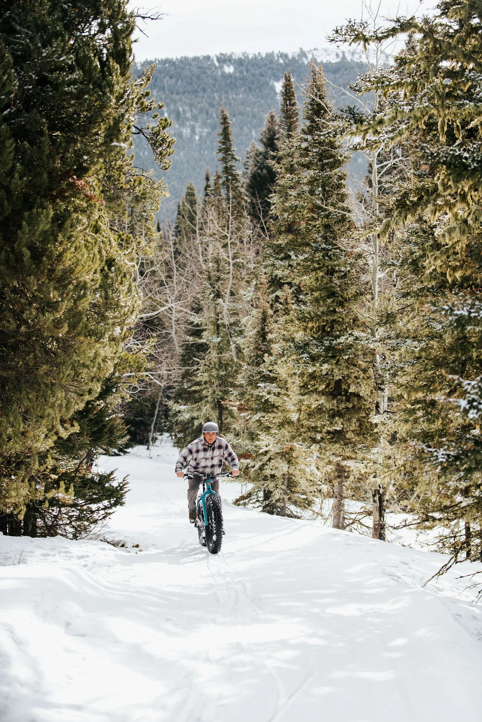
Narrow Gauge Trails
Venture into the snowy woods
These trails are groomed with a snowmobile to create a smoothed surface for fat biking, snowshoeing, and classic skiing. At around 10’ wide, they offer an intimate feeling of being out in the woods, traveling through the forest at a more leisurely pace. Our 9km (5.6 miles) of narrow gauge trails are perfect for looking for mammal tracks in the snow, listening to the birds, and watching for wildlife. This trail system begins and ends at the Nordic & Trail Center.
Narrow Gauge Trail Etiquette and Rules
In places, the narrow gauge trails parallel and intersect groomed ski trails. Please be mindful that narrow gauge traffic yields to traffic on the main ski trails. Be on the lookout for caution signs reminding you of upcoming trail crossings.
All narrow gauge trails are bidirectional and multi-use. Be prepared to encounter other trail users, whether they are fatbikers, snowshoers, or skiers.
Fatbiking enthusiasts: please check the daily grooming report before venturing out — fatbiking is restricted to firm snow conditions that will support bike travel. If you are sinking in more than 2", the snow is too soft for riding. Helmets are required.
All narrow gauge trails are two-directional.
Mid-Mountain Narrow Gauge: Trails 5 & 6
Trail 5: 1.1 km / 0.7 miles
Trail 6: 1.4 km / 0.9 miles
These beginner-friendly trails meander through the mid-mountain area of Crosscut past Jane’s Gate and the mid-mountain meadow which features beautiful mountain vistas. The two trails meet and terminate above the Warming Shelter. They can be linked together for a lovely loop with a stopover at the Warming Shelter for a break and a snack. Both trails provide access the outer narrow gauge trails (Trails 5, 6, and 7).
Southern Narrow Gauge: Trails 1, 2, 3 & 4
Trail 1: 1.3 km / 0.8 mi
Trail 2: 0.5 km / 0.4 mi
Trail 3: 1.0 km / 0.6 mi
Trail 4: 1.0 km / 0.6 mi
These beginner and intermediate trails explore the southern portion of Crosscut traversing through conifer and aspen forest as well as open meadows. Look for areas of lichen covered trees and fantastic views of the Bridger Mountains. Trail 4 adds an additional loop to Trail 3 for those looking for a longer adventure. For beginners wanting to avoid intermediate terrain, the trails are two-way so you are welcome to turn around at any point and head back the way you came.
Outer Narrow Gauge: Trails 7, 8 & 9
Trail 7: 0.8 km / 0.5 miles
Trail 8: 1.0 km / 0.6 miles
Trail 9: 0.9 km / 0.55 miles
The outer narrow gauge offers a deep woods experience. While not actually that far from the Nordic & Trail Center, you’ll feel a world away once you get to Trail 7. These trails feature fun descents, challenging climbs, and sharp turns. The trails make a 2km-long loop around Downey’s Butte with a cutoff shortcut that allows you to bypass a steeper section of trail if desired. Trail 7 and 9 are intermediate level while Trail 8 is advanced.